Engineering drawing

Elements area

Taxonomy

Code

DXXXX-XXX-009-008

Scope note(s)

  • At Pacific Northwest Railroad Archive, engineering drawings providing the form and dimensions of railroad structures such as bridges, tunnels and depots.

Source note(s)

Display note(s)

    Equivalent terms

    Engineering drawing

    • UF Physical plant drawing

    • UF Technical drawings

    Associated terms

    Engineering drawing

      3 Archival description results for Engineering drawing

      US MnSpGNR E0481-003-009-008-007-Dakota Division · Item · 1957-1969
      Part of Great Northern Railway Historical Society Clearance Diagrams

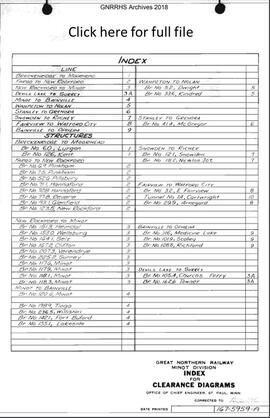
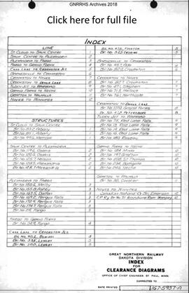
      The Dakota Division file contains clearance diagrams for 12 railway line segments divided at Saint Cloud, Minnesota; Sauk Centre, Minnesota; Alexandria, Minnesota; Fargo, North Dakota; Grand Forks, North Dakota; Cass Lake, Minnesota; Crookston Junction, Minnesota; Barnesville, Minnesota; Crookston, Minnesota; Noyes, Minnesota; Devils Lake, North Dakota; Tilden Junction, Minnesota; Warroad, Minnesota; Grand Forks, North Dakota; Neche, North Dakota; Grafton, North Dakota; Walhalla, North Dakota; and Winnipeg, Manitoba. Individual segment diagrams appear to have been updated in the period between 1957 and 1969.

      US MnSpGNR E0045A-003-009-008-001-JSBP1238 · Item · 1968
      Part of Great Northern Railway- Blueprint-Authorization for Expenditure Collection

      Great Northern Railway Historical Society Blueprint Collection JSBP1238, Devils Lake, North Dakota, 1968. Great Northern Blueprint Number 230-5248-A, Proposed Bridge Number 124.7. General Plan. Interstate Commerce Commission Account Number 6, Bridges, Trestles, and Culverts. Other ICC account descriptions: ICC Account Number 6, Bridge.

      US MnSpGNR E0481-003-009-008-007-Minot Division · Item · 1957-1969
      Part of Great Northern Railway Historical Society Clearance Diagrams

      The Minot Division file conains clearance diagrams for 10 railway line segments divided at Breckenridge, Minnesota; Moorhead, Minnesota; Fargo, North Dakota; New Rockford, North Dakota; Minot, North Dakota; Devils Lake, North Dakota; Surrey, North Dakota; Bainville, Montana; Wahpeton, North Dakota; Nolan, North Dakota; Stanley, North Dakota; Grenora, North Dakota; Snowden, Montana; Richey, Montana; Fairview, Montana; Watford City, North Dakota and Opheim, Montana. Individual segment diagrams appear to have been updated in the period between 1957 and 1969.