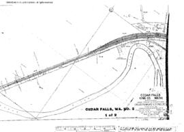
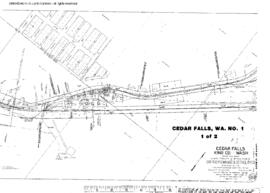
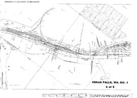
Plat Map of Milwaukee Road facilities at Cedar Falls, Washington, May 15, 1925, Sheet Number 2, Line Segment 397, showing the Easton-Maple Valley line.
Plat Map of Milwaukee Road facilities at Cedar Falls, Washington, December 8, 1925, Sheet Number 1, Line Segment 397, showing the Easton-Maple Valley line.
Plat Map of Milwaukee Road facilities at Cedar Falls, Washington, December 8, 1925, Sheet Number 2, Line Segment 397, showing the Easton-Maple Valley line.
Plat Map of Milwaukee Road facilities at Cedar Falls, Washington, May 15, 1925, Sheet Number 1, Line Segment 397, showing the Easton-Maple Valley line.
Milwaukee Road map, Cedar Falls, 1915. Other subject categories: Right of Way and Track Map
Milwaukee Road Engineering Drawing: Troughs, Plates, Casting, Bridge 2141.6 (FF122) - Taylor Creek, west of Cedar Falls, Washington, Line Segment 397, Milepost 2141.6. Sheet 391 - 8625 - 3, undated.
Milwaukee Road Engineering Drawing: Top Lateral Bracing, Bridge 5.2 (FF912) - Snoqualmie River, north of Cedar Falls, Washington, Line Segment 398, Milepost 5.2. Sheet 391 - 8646 - 9, undated.