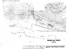
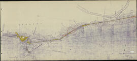
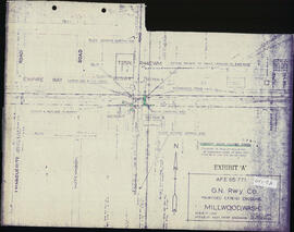
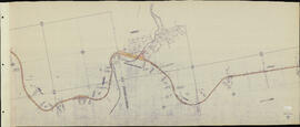
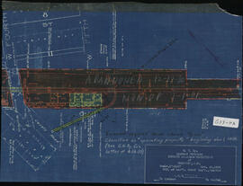
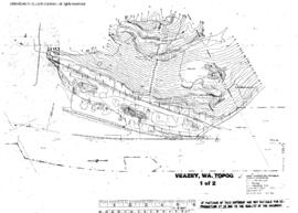
Plat Map of Northern Pacific facilities at Veazey, Washington, January 22, 1980, Sheet Number Topographical map., Line Segment 411, showing the Palmer Junction-Meeker line.
Spokane, Coeur d'Alene and Palouse Railroad Plat Map, Spokane, Washington, Orchard Avenue, Spokane, Coeur d'Alene and Palouse Washington Volume 1 Map 02b, undated.
Spokane, Coeur d'Alene and Palouse Railroad Plat Map, Spokane, Washington, Milepost 1-5, Spokane, Coeur d'Alene and Palouse Washington Volume 1 Map 01, 1923.
Spokane, Coeur d'Alene and Palouse Railroad Plat Map, Millwood, Washington, Millwood Easement, Spokane, Coeur d'Alene and Palouse Washington Volume 1 Map 02a, undated.
Spokane, Coeur d'Alene and Palouse Railroad Plat Map, West Fairfield to Fairfield, Washington, West Fairfield to Fairfield connection, Spokane, Coeur d'Alene and Palouse Washington Volume 2 Map 08, undated.
Spokane, Coeur d'Alene and Palouse Railroad Plat Map, Waverly, Washington, Milepost 34, Spokane, Coeur d'Alene and Palouse Washington Volume 2 Map 09a, undated.
Spokane, Coeur d'Alene and Palouse Railroad Plat Map, Waverly to Jefferson, Washington, Milepost 32-37, Spokane, Coeur d'Alene and Palouse Washington Volume 2 Map 09, undated.
Spokane, Coeur d'Alene and Palouse Railroad Plat Map, Thornton, Washington, Thornton Ditch. Milepost 55+, Spokane, Coeur d'Alene and Palouse Washington Volume 3 Map 04a, undated.
Spokane, Coeur d'Alene and Palouse Railroad Plat Map, Thornton to Trestle Creek, Washington, Milepost 53-56, Spokane, Coeur d'Alene and Palouse Washington Volume 3 Map 04, undated.