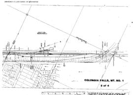
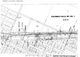
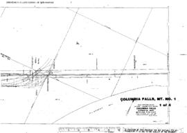
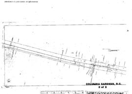
Plat Map of Great Northern facilities at Collins, Montana, August 1, 1968, Sheet Number 2, Line Segment 354, showing the Great Falls-Sweet Grass line.
Plat Map of Great Northern facilities at Columbia Falls, Montana, July 1, 1959, Sheet Number 2, Line Segment 36, showing the Pacific Junction-Sandpoint Junction line.
Plat Map of Great Northern facilities at Columbia Falls, Montana, July 1, 1959, Sheet Number 3, Line Segment 36, 388, showing the Pacific Junction-Sandpoint Junction line, Columbia Falls-Somers line.
Plat Map of Great Northern facilities at Columbia Falls, Montana, July 1, 1959, Sheet Number 1, Line Segment 36, showing the Pacific Junction-Sandpoint Junction line.
Plat Map of Great Northern facilities at Columbia Falls, Montana, July 1, 1959, Sheet Number 4, Line Segment 36, 388, showing the Pacific Junction-Sandpoint Junction line, Columbia Falls-Somers line.
Plat Map of Great Northern facilities at Columbia Gardens, British Columbia, December 28, 1944, Sheet Number 2, Line Segment 391, showing the Nelson-Boundary line.
Plat Map of Great Northern facilities at Columbia Gardens, British Columbia, December 28, 1944, Sheet Number 1, Line Segment 391, showing the Nelson-Boundary line.
Plat Map of Great Northern facilities at Columbia River, Washington, June 30, 1945, Sheet Number 2, Line Segment 37, showing the Sandpoint Junction-Everett Junction line.
Plat Map of Great Northern facilities at Columbia River, Washington, June 30, 1945, Sheet Number 1, Line Segment 37, 386, showing the Sandpoint Junction-Everett Junction line, Mansfield-Columbia River line.
Plat Map of Great Northern facilities at Colville, Washington, June 1, 1963, Sheet Number 1, Line Segment 376, showing the Boundary-Dean-Kettle Falls line.