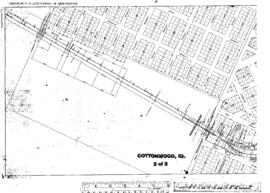
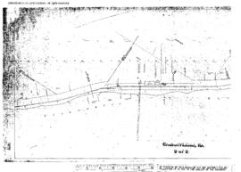
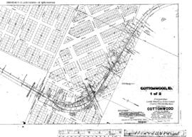
Plat Map of Canadian Pacific facilities at Cottonwood, Idaho, April 15, 1915, Sheet Number 1, Line Segment 460, showing the Spalding-Grangeville line.
Plat Map of Canadian Pacific facilities at Cottonwood, Idaho, April 15, 1915, Sheet Number 2, Line Segment 460, showing the Spalding-Grangeville line.
Plat Map of Canadian Pacific facilities at Cherrylane, Idaho, undated, Sheet Number 1, Line Segment 461, showing the Orofino-Stites line.
Plat Map of Canadian Pacific facilities at Cherrylane, Idaho, undated, Sheet Number 2, Line Segment 461, showing the Orofino-Stites line.
Plat Map of Canadian Pacific facilities at Arrow, Idaho, June 8, 1889, Sheet Number 1, Line Segment 459, 462, showing the Arrow-Lewiston line, Arrow-Headquarters line.
Plat Map of Canadian Pacific facilities at Arrow, Idaho, undated, Sheet Number 1, Line Segment 459, showing the Arrow-Lewiston line.
Plat Map of Canadian Pacific facilities at Arrow, Idaho, June 8, 1889, Sheet Number 2, Line Segment 459, 462, showing the Arrow-Lewiston line, Arrow-Headquarters line.
Plat Map of Canadian Pacific facilities at Arrow, Idaho, January 9, 1914, Sheet Number 2, Line Segment 459, 462, showing the Arrow-Lewiston line, Arrow-Headquarters line.
Plat Map of Canadian Pacific facilities at Arrow, Idaho, January 9, 1914, Sheet Number 1, Line Segment 459, 462, showing the Arrow-Lewiston line, Arrow-Headquarters line.
Plat Map of Canadian Pacific facilities at Ahsahka, Idaho, October 10, 1910, Sheet Number 2, Line Segment 462, showing the Arrow-Headquarters line.