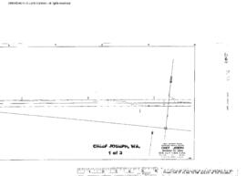
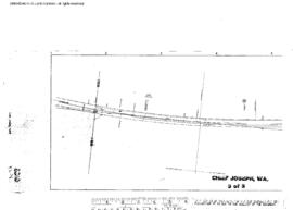
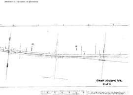
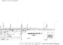
Plat Map of Great Northern facilities at Chillowist, Washington, July 1, 1914, Drawing Number 8279-1, Sheet Number 2, Line Segment 387, showing the Oroville-Wenatchee line.
Plat Map of Great Northern facilities at Chief Joseph, Washington, September 1, 1953, Sheet Number 1, Line Segment 387, showing the Oroville-Wenatchee line.
Plat Map of Great Northern facilities at Chief Joseph, Washington, September 1, 1953, Sheet Number 3, Line Segment 387, showing the Oroville-Wenatchee line.
Plat Map of Great Northern facilities at Chief Joseph, Washington, September 1, 1953, Sheet Number 2, Line Segment 387, showing the Oroville-Wenatchee line.
Plat Map of Great Northern facilities at Chewelah, Washington, undated, Sheet Number 1, Line Segment 376, showing the Boundary-Dean-Kettle Falls line.
Plat Map of Great Northern facilities at Chewelah, Washington, undated, Sheet Number 2, Line Segment 376, showing the Boundary-Dean-Kettle Falls line.
Plat Map of Great Northern facilities at Chewelah, Washington, October 1, 1963, Sheet Number 1, Line Segment 376, showing the Boundary-Dean-Kettle Falls line.
Plat Map of Great Northern facilities at Chewelah, Washington, October 1, 1963, Sheet Number 2, Line Segment 376, showing the Boundary-Dean-Kettle Falls line.
Plat Map of Great Northern facilities at Chewelah, Washington, July 1, 1928, Sheet Number 2, Line Segment 376, showing the Boundary-Dean-Kettle Falls line.
Plat Map of Great Northern facilities at Chewelah, Washington, July 1, 1928, Sheet Number 1, Line Segment 376, showing the Boundary-Dean-Kettle Falls line.