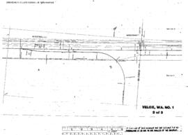
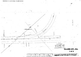
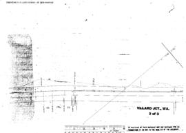
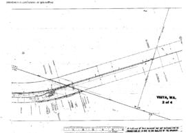
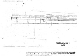
Plat Map of Northern Pacific facilities at Velox, Washington, October 31, 1943, Sheet Number 3, Line Segment 45, showing the Kootenai-Spokane line.
Plat Map of Northern Pacific facilities at Velox, Washington, October 31, 1943, Sheet Number 2, Line Segment 45, showing the Kootenai-Spokane line.
Plat Map of Northern Pacific facilities at Velox, Washington, May 30, 1979, Sheet Number 1, Line Segment 45, showing the Kootenai-Spokane line.
Plat Map of Northern Pacific facilities at Venner, Washington, December 9, 1975, Sheet Number 1, Line Segment 447, showing the Toppenish-White Swan line.
Plat Map of Northern Pacific facilities at Victor, Montana, July 23, 1929, Sheet Number 1, Line Segment 333, showing the Missoula-Darby line.
Plat Map of Northern Pacific facilities at Victor, Montana, July 23, 1929, Sheet Number 2, Line Segment 333, showing the Missoula-Darby line.
Plat Map of Northern Pacific facilities at Villard Junction, Washington, September 13, 1954, Sheet Number 1, Line Segment 435, showing the Riparia-Attalia line.
Plat Map of Northern Pacific facilities at Villard Junction, Washington, September 13, 1954, Sheet Number 2, Line Segment 435, showing the Riparia-Attalia line.
Plat Map of Northern Pacific facilities at Villard Junction, Washington, September 13, 1954, Sheet Number 3, Line Segment 435, showing the Riparia-Attalia line.
Plat Map of Northern Pacific facilities at Vista, Washington, September 30, 1930, Sheet Number 2, Line Segment 48, showing the Pasco-Ellensburg line.