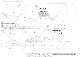
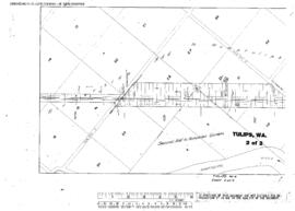
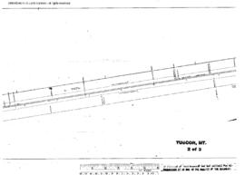
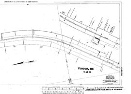
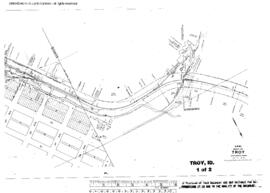
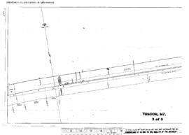
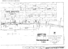
Plat Map of Northern Pacific facilities at Troy, Idaho, February 13, 1941, Sheet Number 1, Line Segment 384, showing the Marshall-Arrow line.
Plat Map of Northern Pacific facilities at Troy, Idaho, February 13, 1941, Sheet Number 2, Line Segment 384, showing the Marshall-Arrow line.
Plat Map of Northern Pacific facilities at Tulips, Washington, February 6, 1914, Sheet Number 1, Line Segment 402, showing the Saint Clair-Moclips line.
Plat Map of Northern Pacific facilities at Tulips, Washington, February 6, 1914, Sheet Number 2, Line Segment 402, showing the Saint Clair-Moclips line.
Plat Map of Northern Pacific facilities at Tuscor, Montana, October 7, 1958, Sheet Number 2, Line Segment 44, showing the Paradise-Kootenai line.
Plat Map of Northern Pacific facilities at Tuscor, Montana, October 7, 1958, Sheet Number 1, Line Segment 44, showing the Paradise-Kootenai line.
Plat Map of Northern Pacific facilities at Tuscor, Montana, October 7, 1958, Sheet Number 3, Line Segment 44, showing the Paradise-Kootenai line.
Plat Map of Northern Pacific facilities at Twin Bridges, Montana, May 11, 1915, Sheet Number 2, Line Segment 339, showing the Whitehall-Alder line.
Plat Map of Northern Pacific facilities at Twin Bridges, Montana, May 11, 1915, Sheet Number 1, Line Segment 339, showing the Whitehall-Alder line.
Plat Map of Northern Pacific facilities at Umtanum, Washington, October 28, 1939, Sheet Number 1, Line Segment 48, showing the Pasco-Ellensburg line.