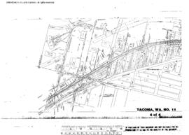
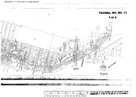
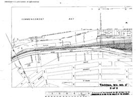
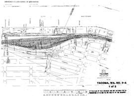
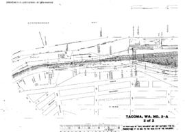
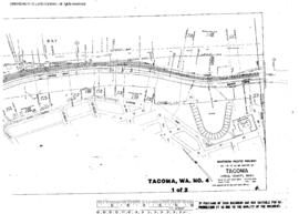
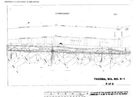
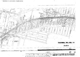
Plat Map of Northern Pacific facilities at Tacoma, Washington, October 30, 1944, Sheet Number 3, Line Segment 400, 608, showing the Prairie line, South Tacoma.
Plat Map of Northern Pacific facilities at Tacoma, Washington, October 30, 1944, Sheet Number 4, Line Segment 608, showing the Prairie line, South Tacoma, government warehouse spurs.
Plat Map of Northern Pacific facilities at Tacoma, Washington, October 30, 1944, Sheet Number 1, Line Segment 400, 608, showing the Prairie line, Nalley Valley.
Plat Map of Northern Pacific facilities at Tacoma, Washington, October 30, 1944, Sheet Number 2, Line Segment 400, 608, showing the Prairie line, Nalley Valley.
Plat Map of Northern Pacific facilities at Tacoma, Washington, July 24, 1946, Sheet Number 2, Line Segment 608, showing the Half Moon Yard,ÿwest end.
Plat Map of Northern Pacific facilities at Tacoma, Washington, July 24, 1946, Sheet Number 1, Line Segment 608, showing the Half Moon Yard.
Plat Map of Northern Pacific facilities at Tacoma, Washington, August 15, 1946, Sheet Number 1, Line Segment 608, showing the Half Moon Yard.
Plat Map of Northern Pacific facilities at Tacoma, Washington, August 15, 1946, Sheet Number 2, Line Segment 608, showing the Half Moon Yard, west end.
Plat Map of Northern Pacific facilities at Tacoma, Washington, February 1, 1951, Sheet Number 1, Line Segment 608, showing the Waterfront.
Plat Map of Northern Pacific facilities at Tacoma, Washington, May 1, 1951, Sheet Number 2, Line Segment 608, showing the McCarver Street.