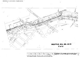
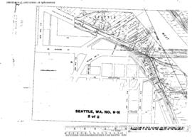
Plat Map of Northern Pacific facilities at Seattle, Washington, September 24, 1945, Sheet Number 2, showing the East Waterway, 1st Avenue South-5th Avenue South, industry spurs.
Plat Map of Northern Pacific facilities at Seattle, Washington, December 7, 1946, Sheet Number 2, showing the Lake Union line, North Halladay Street-N Etruria Street.
Plat Map of Northern Pacific facilities at Seattle, Washington, January 8, 1946, Sheet Number 1, Line Segment 430, showing the Seattle-Argo line, Argo interlocking.
Plat Map of Northern Pacific facilities at Seattle, Washington, December 7, 1946, Sheet Number 1, showing the Lake Union line, Westlake Avenue North, north end.
Plat Map of Northern Pacific facilities at Seattle, Washington, January 8, 1946, Sheet Number 2, Line Segment 51, showing the Seattle-Tacoma line, Georgetown.
Plat Map of Northern Pacific facilities at Seattle, Washington, June 1, 1947, Sheet Number 2, showing the West Marginal Way, Iowa Avenue Southwest, industry spurs.
Plat Map of Northern Pacific facilities at Seattle, Washington, July 1, 1947, Sheet Number 3, Line Segment 51, showing the Seattle-Tacoma line, Georgetown.
Plat Map of Northern Pacific facilities at Seattle, Washington, June 1, 1947, Sheet Number 1, showing the Spokane Street, Harbor Island, Duwamish drawbridge, West Marginal Way.
Plat Map of Northern Pacific facilities at Seattle, Washington, July 1, 1947, Sheet Number 1, Line Segment 430, showing the Seattle-Argo line, Shore line, Argo Yard, Union Pacific roundhouse.
Plat Map of Northern Pacific facilities at Seattle, Washington, June 1, 1947, Sheet Number 1, Line Segment 403, showing the Seattle-Sumas line, gas works, Interlake Avenue North-Sunnyside Avenue N.