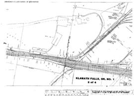
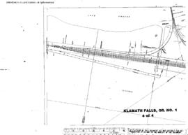
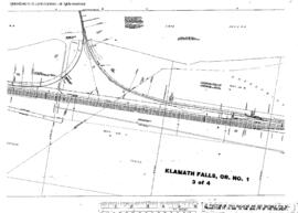
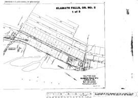
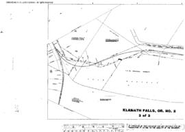
Plat Map of Great Northern facilities at Klamath Falls, Oregon, June 1, 1962, Sheet Number 2, Line Segment 55, showing the Riverside spur.
Plat Map of Great Northern facilities at Klamath Falls, Oregon, March 1, 1962, Sheet Number 2, Line Segment 55, showing the Klamath Falls yard, Southern Pacific interchange.
Plat Map of Great Northern facilities at Klamath Falls, Oregon, March 1, 1962, Sheet Number 4, Line Segment 55, showing the Klamath Falls yard, Southern Pacific interchange.
Plat Map of Great Northern facilities at Klamath Falls, Oregon, March 1, 1962, Sheet Number 1, Line Segment 55, showing the Klamath Falls yard, industry spurs.
Plat Map of Great Northern facilities at Klamath Falls, Oregon, March 1, 1962, Sheet Number 3, Line Segment 55, showing the Klamath Falls yard, Southern Pacific interchange.
Plat Map of Great Northern facilities at Klamath Falls, Oregon, June 1, 1962, Sheet Number 1, Line Segment 55, showing the Riverside spur.
Plat Map of Great Northern facilities at Klamath Falls, Oregon, June 1, 1962, Sheet Number 3, Line Segment 55, showing the Riverside spur.
Plat Map of Great Northern facilities at Klamath Falls, Oregon, August 1, 1930, Sheet Number 3, Line Segment 55, showing the Weyerhaeuser trackage.
Plat Map of Great Northern facilities at Klamath Falls, Oregon, June 1, 1930, Sheet Number 1, Line Segment 55, showing the Klamath Falls yard, fruit spur.
Plat Map of Great Northern facilities at Klamath Falls, Oregon, August 1, 1930, Sheet Number 2, Line Segment 55, showing the Weyerhaeuser trackage.