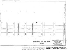
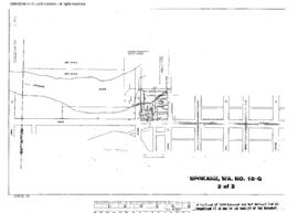
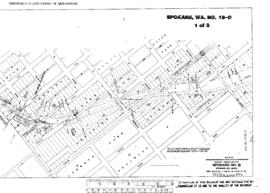
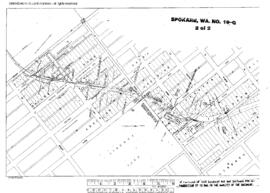
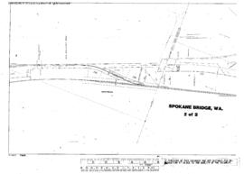
Plat Map of Great Northern facilities at Spokane, Washington, May 1, 1942, Sheet Number 2, Line Segment 653, showing the Hillyard Shop, industry spur.
Plat Map of Great Northern facilities at Spokane, Washington, July 1, 1928, Drawing Number 01870-18, Sheet Number 2, Line Segment 382, showing the Coeur d'Alene-Erie Street yard line.
Plat Map of Great Northern facilities at Spokane, Washington, December 1, 1927, Sheet Number 1, Line Segment n/a, showing the Former right of way.
Plat Map of Great Northern facilities at Spokane, Washington, December 1, 1927, Sheet Number 2, Line Segment n/a, showing the Former right of way.
Plat Map of Great Northern facilities at Spokane Bridge, Washington, December 31, 1927, Sheet Number 1, Line Segment 375, showing the Spokane-Coeur d'Alene line.
Plat Map of Great Northern facilities at Spokane Bridge, Washington, December 31, 1927, Sheet Number 2, Line Segment 375, showing the Spokane-Coeur d'Alene line.
Plat Map of Great Northern facilities at South Nelson, British Columbia, November 1, 1965, Sheet Number 1, Line Segment 391, showing the Nelson-Boundary line.
Plat Map of Great Northern facilities at South Nelson, British Columbia, November 1, 1965, Sheet Number 2, Line Segment 391, showing the Nelson-Boundary line.
Plat Map of Great Northern facilities at South Klamath, Oregon, March 1, 1962, Sheet Number 3, Line Segment 639, showing the South Klamath yard, wye.