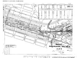
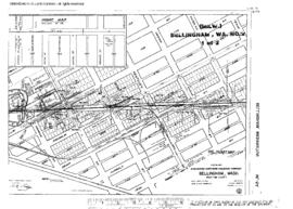
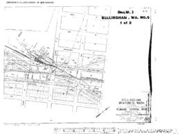
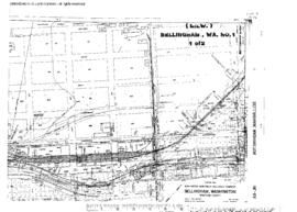
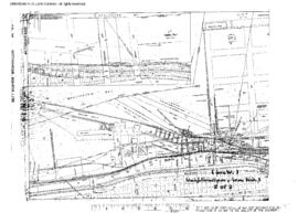
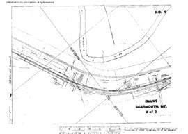
Plat Map of Milwaukee Road facilities at Bearmouth, Montana, September 15, 1915, Sheet Number 2, showing the Milwaukee Road mainline, Northern Pacific mainline.
Plat Map of Milwaukee Road facilities at Bellingham, Washington, June 30, 1912, Sheet Number 2, Line Segment 616, showing the Bellingham-Cornwall line, industry spurs, Northern Pacific depot, freight house.
Plat Map of Milwaukee Road facilities at Bellingham, Washington, June 30, 1912, Sheet Number 1, Line Segment 616, showing the Bellingham-Cornwall line, Northern Pacific interchange.
Plat Map of Milwaukee Road facilities at Bellingham, Washington, May 1, 1916, Sheet Number 2, Line Segment 616, showing the Bellingham-Cornwall line, dock spurs.
Plat Map of Milwaukee Road facilities at Bellingham, Washington, May 1, 1916, Sheet Number 1, Line Segment 616, showing the Bellingham-Cornwall line, dock and industry spurs, Northern Pacific trackage.
Plat Map of Milwaukee Road facilities at Bellingham, Washington, June 16, 1917, Sheet Number 1, Line Segment 399, showing the Bellingham-Sumas line, industry spur.
Plat Map of Milwaukee Road facilities at Bellingham, Washington, June 16, 1917, Sheet Number 2, Line Segment 399, showing the Bellingham-Sumas line, industry spurs.
Plat Map of Milwaukee Road facilities at Bellingham, Washington, December 12, 1928, Sheet Number 1, Line Segment 616, showing the Bellingham-Cornwall line, depot, freight house, roundhouse, Great Northern, Northern Pacific trackage.
Plat Map of Milwaukee Road facilities at Bellingham, Washington, December 12, 1928, Sheet Number 2, Line Segment 616, showing the Bellingham-Cornwall line, dock and industry spurs, Great Northern, Northern Pacific trackage.
Plat Map of Milwaukee Road facilities at Bellingham, Washington, June 22, 1932, Sheet Number 1, Line Segment 399, showing the Bellingham-Sumas line, waterfront.