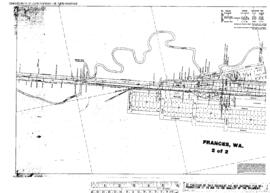
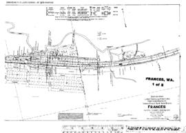
Plat Map of Northern Pacific facilities at Frances, Washington, August 29, 1916, Sheet Number 1, Line Segment 420, showing the Chehalis-South Bend line.
Plat Map of Northern Pacific facilities at Frances, Washington, August 29, 1916, Sheet Number 2, Line Segment 420, showing the Chehalis-South Bend line.
Plat Map of Northern Pacific facilities at Fortson, Washington, December 11, 1912, Sheet Number 1, Line Segment 406, showing the Darrington-Kruse Junction line.
Plat Map of Northern Pacific facilities at Fortson, Washington, December 11, 1912, Sheet Number 2, Line Segment 406, showing the Darrington-Kruse Junction line.
Plat Map of Northern Pacific facilities at Fort Lewis, Washington, February 17, 1909, Sheet Number 1, Line Segment 401, showing the Lakeview-Nisqually line.
Plat Map of Northern Pacific facilities at Fort Lewis, Washington, February 17, 1909, Sheet Number 2, Line Segment 401, showing the Lakeview-Nisqually line.
Plat Map of Northern Pacific facilities at Fort Lewis, Washington, February 18, 1908, Sheet Number 1, Line Segment 401, showing the Lakeview-Nisqually line, du Pont Powder Company trackage.
Plat Map of Northern Pacific facilities at Flint, Washington, August 20, 1917, Sheet Number 1, Line Segment 448, showing the Gibbon-Parker line.
Plat Map of Northern Pacific facilities at Flint, Washington, August 20, 1917, Sheet Number 2, Line Segment 448, showing the Gibbon-Parker line.