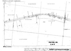
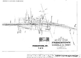
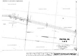
Plat Map of Northern Pacific facilities at Fulton, Oregon, February 26, 1913, Sheet Number 1, Line Segment 451, showing the Attalia-Union Pacific Connection (Pendleton) line.
Plat Map of Northern Pacific facilities at Fulton, Oregon, February 26, 1913, Sheet Number 2, Line Segment 451, showing the Attalia-Union Pacific Connection (Pendleton) line.
Plat Map of Northern Pacific facilities at Frys, Washington, May 16, 1917, Sheet Number 2, Line Segment 378, showing the Cheney-Coulee Cityÿline.
Plat Map of Northern Pacific facilities at Frys, Washington, May 16, 1917, Sheet Number 1, Line Segment 378, showing the Cheney-Coulee City line.
Plat Map of Northern Pacific facilities at Fruitvale, Washington, March 14, 1977, Sheet Number 1, Line Segment 444, showing the Yakima-Naches line.
Plat Map of Northern Pacific facilities at Fruitvale, Washington, March 14, 1917, Sheet Number 2, Line Segment 444, showing the Yakima-Naches line.
Plat Map of Northern Pacific facilities at Frischnecht, Washington, undated, Sheet Number 1, Line Segment 378, showing the Cheney-Coulee City line.
Plat Map of Northern Pacific facilities at Frenchtown, Montana, April 3, 1933, Sheet Number 3, Line Segment 43, showing the De Smet-Paradise line.
Plat Map of Northern Pacific facilities at Frenchtown, Montana, April 3, 1933, Sheet Number 2, Line Segment 43, showing the De Smet-Paradise line.
Plat Map of Northern Pacific facilities at Frenchtown, Montana, April 3, 1933, Sheet Number 1, Line Segment 43, showing the De Smet-Paradise line.