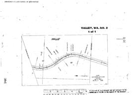
Plat Map of Great Northern facilities at Valley, Washington, July 1, 1960, Sheet Number 1, Line Segment 376, showing the Dean-Kettle Falls line, Lane Mountain Silica Company spur.
Plat Map of Great Northern facilities at Vancouver, British Columbia, April 1, 1923, Drawing Number 9700-5, Sheet Number 2, Line Segment 600, showing the Commercial Street-Clark Dr industry spurs.
Plat Map of Great Northern facilities at Vancouver, British Columbia, April 1, 1923, Drawing Number 9700-5, Sheet Number 1, Line Segment 600, showing the Templeton Dr-Commercial Street.
Plat Map of Great Northern facilities at Vancouver, British Columbia, May 1, 1933, Sheet Number 2, Line Segment 424, 600, showing the Waterfront,?¨Rogers Street-Hawks Street, dock spurs.
Plat Map of Great Northern facilities at Vancouver, British Columbia, May 1, 1933, Sheet Number 1, Line Segment 424, 600, showing the Parker Street-Burrard Inlet.
Plat Map of Great Northern facilities at Vancouver, British Columbia, April 1, 1937, Sheet Number 1, Line Segment 600, showing the False Creek, Main Street-Cook Street, industry spurs.
Plat Map of Great Northern facilities at Vancouver, British Columbia, April 1, 1937, Sheet Number 2, Line Segment 600, showing the False Creek, Quebec Street-Crowe Street, industry spurs.
Plat Map of Great Northern facilities at Vancouver, British Columbia, March 1, 1954, Sheet Number 2, Line Segment 600, showing the Cornett Road-Rupert Street, industry spurs.
Plat Map of Great Northern facilities at Vancouver, British Columbia, June 1, 1954, Sheet Number 1, Line Segment 600, showing the Renfrew Street-Gilmore Avenue.
Plat Map of Great Northern facilities at Vancouver, British Columbia, June 1, 1954, Sheet Number 2, Line Segment 600, showing the Boundary Road-Rupert Street, industry spurs.