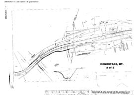
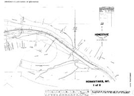
Plat Map of Northern Pacific facilities at Homestake, Montana, May 1, 1957, Sheet Number 1, Line Segment 326, showing the Logan-Butte line.
Plat Map of Northern Pacific facilities at Homestake, Montana, May 1, 1957, Sheet Number 2, Line Segment 326, showing the Logan-Butte line.
Plat Map of Northern Pacific facilities at Holtzinger, Washington, December 2, 1931, Sheet Number 2, Line Segment 445, showing the Brace-Tieton line.
Plat Map of Northern Pacific facilities at Holtzinger, Washington, December 2, 1931, Sheet Number 1, Line Segment 445, showing the Brace-Tieton line.
Plat Map of Northern Pacific facilities at Holmes, Washington, May 19, 1945, Sheet Number 1, Line Segment 48, showing the Pasco-Ellensburg line.
Plat Map of Northern Pacific facilities at Holmes, Washington, May 19, 1945, Sheet Number 2, Line Segment 48, showing the Pasco-Ellensburg line.
Plat Map of Northern Pacific facilities at Holcomb, Washington, September 6, 1916, Sheet Number 1, Line Segment 420, showing the Chehalis-South Bend line.
Plat Map of Northern Pacific facilities at Holcomb, Washington, September 6, 1916, Sheet Number 2, Line Segment 420, showing the Chehalis-South Bend line.
Plat Map of Northern Pacific facilities at Hite, Washington, September 3, 1913, Sheet Number 1, Line Segment 378, showing the Cheney-Coulee City line.
Plat Map of Northern Pacific facilities at Hite, Washington, September 3, 1913, Sheet Number 2, Line Segment 378, showing the Cheney-Coulee City line.