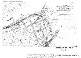
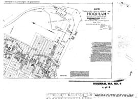
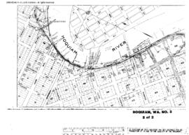
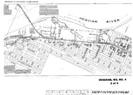
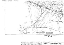
Plat Map of Northern Pacific facilities at Hoquiam, Washington, April 8, 1913, Sheet Number 3, Line Segment 402, showing the Saint Clair-Moclips line, wye.
Plat Map of Northern Pacific facilities at Hoquiam, Washington, August 15, 1912, Sheet Number 3, Line Segment 402, showing the Saint Clair-Moclips line, Hoquiam River drawbridge, mill spurs.
Plat Map of Northern Pacific facilities at Hoquiam, Washington, August 15, 1912, Sheet Number 1, Line Segment 402, showing the Saint Clair-Moclips line, riverside spur.
Plat Map of Northern Pacific facilities at Hoquiam, Washington, August 15, 1912, Sheet Number 1, Line Segment 402, showing the Saint Clair-Moclips line, mill spurs.
Plat Map of Northern Pacific facilities at Hoquiam, Washington, August 15, 1912, Sheet Number 2, Line Segment 402, showing the Saint Clair-Moclips line, riverside spur.
Plat Map of Northern Pacific facilities at Hoquiam, Washington, August 15, 1912, Sheet Number 2, Line Segment 402, showing the Saint Clair-Moclips line, Hoquiam River drawbridge, mill spurs.
Plat Map of Northern Pacific facilities at Hope, Idaho, October 7, 1910, Sheet Number 1, Line Segment 44, showing the Paradise-Kootenai line.
Plat Map of Northern Pacific facilities at Hope, Idaho, October 7, 1910, Sheet Number 2, Line Segment 44, showing the Paradise-Kootenai line.
Plat Map of Northern Pacific facilities at Hope, Idaho, October 7, 1910, Sheet Number 3, Line Segment 44, showing the Paradise-Kootenai line.
Plat Map of Northern Pacific facilities at Hope, Idaho, October 7, 1910, Sheet Number 4, Line Segment 44, showing the Paradise-Kootenai line.