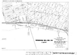
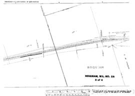
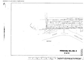
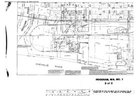
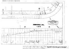
Plat Map of Northern Pacific facilities at Humphrey, Washington, March 26, 1908, Sheet Number 1, Line Segment 49, showing the Ellensburg-Rainier (Auburn) line.
Plat Map of Northern Pacific facilities at Hoquiam, Washington, February 1, 1923, Sheet Number 1, Line Segment 402, showing the Saint Clair-Moclips line, west side.
Plat Map of Northern Pacific facilities at Hoquiam, Washington, February 1, 1923, Sheet Number 3, Line Segment 402, showing the Saint Clair-Moclips line, west side.
Plat Map of Northern Pacific facilities at Hoquiam, Washington, February 1, 1923, Sheet Number 4, Line Segment 402, showing the Saint Clair-Moclips line, west side.
Plat Map of Northern Pacific facilities at Hoquiam, Washington, February 1, 1923, Sheet Number 2, Line Segment 402, showing the Saint Clair-Moclips line, west side.
Plat Map of Northern Pacific facilities at Hoquiam, Washington, November 26, 1915, Sheet Number 1, Line Segment 402, showing the Saint Clair-Moclips line, Hoquiam River drawbridge, mill spurs.
Plat Map of Northern Pacific facilities at Hoquiam, Washington, November 26, 1915, Sheet Number 2, Line Segment 402, showing the Saint Clair-Moclips line, Hoquiam River drawbridge, mill spurs.
Plat Map of Northern Pacific facilities at Hoquiam, Washington, April 8, 1913, Sheet Number 2, Line Segment 402, showing the Saint Clair-Moclips line, Hoquiam River drawbridge, Rayonier trackage.
Plat Map of Northern Pacific facilities at Hoquiam, Washington, April 8, 1913, Sheet Number 1, Line Segment 402, showing the Saint Clair-Moclips line, yard, depot, freighthouse, Hoquiam River drawbridge.
Plat Map of Northern Pacific facilities at Hoquiam, Washington, April 8, 1913, Sheet Number 2, Line Segment 402, showing the Saint Clair-Moclips line, depot, freighthouse, wye.