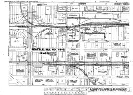
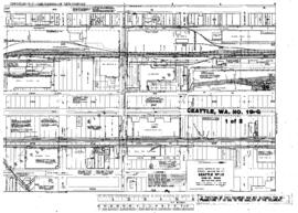
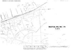
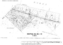
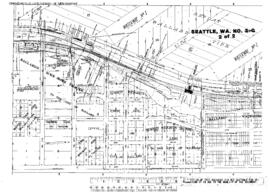
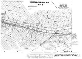
Plat Map of Great Northern facilities at Seattle, Washington, January 1, 1965, Sheet Number 1, Line Segment 619, showing the Mainlines, South Holgate Street-South Forest Street, industry spurs.
Plat Map of Great Northern facilities at Seattle, Washington, January 1, 1965, Sheet Number 2, Line Segment 619, showing the Mainlines, South Lander Street-South Spokane Street, industry spurs.
Plat Map of Great Northern facilities at Seattle, Washington, March 1, 1965, Sheet Number 1, Line Segment 619, showing the Mainline, Salmon Bay.
Plat Map of Great Northern facilities at Seattle, Washington, March 1, 1965, Sheet Number 2, Line Segment 619, showing the Mainline, Salmon Bay.
Plat Map of Great Northern facilities at Seattle, Washington, undated, Sheet Number 2, Line Segment 619, showing the 7th-8th Avenue lines, Northern Pacific Shore line, South McClellan Street-South Court Street.
Plat Map of Great Northern facilities at Seattle, Washington, undated, Sheet Number 2, Line Segment 470, 620, showing the Balmer Yard.
Plat Map of Great Northern facilities at Seattle, Washington, undated, Sheet Number 1, Line Segment 619, showing the Mainline, Richmond Highlands.
Plat Map of Great Northern facilities at Seattle, Washington, undated, Sheet Number 3, Line Segment 619, showing the Mainline, Richmond Highlands.
Plat Map of Great Northern facilities at Seattle, Washington, undated, Sheet Number 7, Line Segment 619, showing the Mainline, Blue Ridge.
Plat Map of Great Northern facilities at Seattle, Washington, undated, Sheet Number 2, Line Segment 619, showing the Mainline, Golden Gardens.