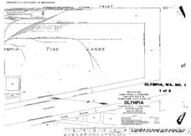
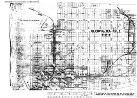
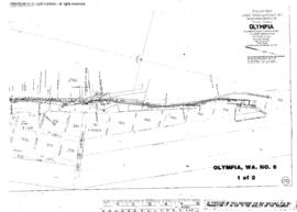
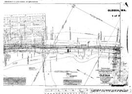
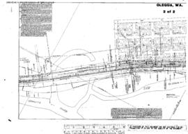
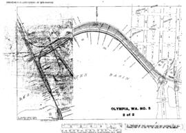
Plat Map of Northern Pacific facilities at Olympia, Washington, January 1, 1954, Sheet Number 2, Line Segment 402, 609, showing the Saint Clair-Moclips line, Des Shutes Basin yard.
Plat Map of Northern Pacific facilities at Olympia, Washington, April 16, 1931, Sheet Number 1, Line Segment 609, showing the Dock spurs.
Plat Map of Northern Pacific facilities at Olympia, Washington, April 16, 1931, Sheet Number 2, Line Segment 609, showing the Waterfront, dock andÿindustry spurs.
Plat Map of Northern Pacific facilities at Olympia, Washington, April 16, 1931, Sheet Number 3, Line Segment 609, showing the Downtown, depot, industry spurs.
Plat Map of Northern Pacific facilities at Olympia, Washington, May 12, 1918, Sheet Number 2, Line Segment 609, showing the West bay line.
Plat Map of Northern Pacific facilities at Olympia, Washington, May 12, 1918, Sheet Number 1, Line Segment 609, showing the West Bay, log dump.
Plat Map of Northern Pacific facilities at Olequa, Washington, August 7, 1915, Sheet Number 1, Line Segment 52, showing the Tacoma-Vancouver line.
Plat Map of Northern Pacific facilities at Olequa, Washington, August 7, 1915, Sheet Number 2, Line Segment 52, showing the Tacoma-Vancouver line.
Plat Map of Northern Pacific facilities at Odair, Washington, March 24, 1936, Sheet Number 3, Line Segment 378, showing the Cheney-Coulee City line.
Plat Map of Northern Pacific facilities at Odair, Washington, March 24, 1936, Sheet Number 2, Line Segment 378, showing the Cheney-Coulee City line.