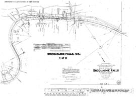
Plat Map of Northern Pacific facilities at Snoqualmie Falls, Washington, November 6, 1914, Sheet Number 1, Line Segment 404, showing the North Bend-Woodinville line.
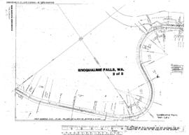
Plat Map of Northern Pacific facilities at Snoqualmie Falls, Washington, November 6, 1914, Sheet Number 2, Line Segment 404, showing the North Bend-Woodinville line.
Plat Map of Northern Pacific facilities at Snoqualmie To North Bend, Washington, July 30, 1982, Sheet Number 1, Line Segment 404, showing the North Bend-Woodinville line.
Plat Map of Northern Pacific facilities at Snoqualmie To North Bend, Washington, July 30, 1982, Sheet Number 4, Line Segment 404, showing the North Bend-Woodinville line.
Plat Map of Northern Pacific facilities at Snoqualmie To North Bend, Washington, July 30, 1982, Sheet Number 2, Line Segment 404, showing the North Bend-Woodinville line.
Plat Map of Northern Pacific facilities at Snoqualmie To North Bend, Washington, July 30, 1982, Sheet Number 3, Line Segment 404, showing the North Bend-Woodinville line.
Plat Map of Northern Pacific facilities at Snoqualmie, Washington, September 1, 1924, Sheet Number 2, Line Segment 404, showing the North Bend-Woodinville line.
Plat Map of Northern Pacific facilities at Snoqualmie, Washington, September 1, 1924, Sheet Number 1, Line Segment 404, showing the North Bend-Woodinville line.
Plat Map of Northern Pacific facilities at South Bend, Washington, January 31, 1942, Sheet Number 2, Line Segment 420, showing the Chehalis-South Bend line.
Plat Map of Northern Pacific facilities at South Bend, Washington, January 31, 1942, Sheet Number 1, Line Segment 420, showing the Chehalis-South Bend line.
Plat Map of Northern Pacific facilities at South Missoula, Montana, March 6, 1929, Sheet Number 1, Line Segment 333, showing the Missoula-Darby line.
Plat Map of Northern Pacific facilities at South Missoula, Montana, March 6, 1929, Sheet Number 2, Line Segment 333, showing the Missoula-Darby line.
Plat Map of Northern Pacific facilities at South Prairie, Washington, April 10, 1920, Sheet Number 1, Line Segment 411, showing the Palmer Junction-Meeker line.
Plat Map of Northern Pacific facilities at South Prairie, Washington, April 10, 1920, Sheet Number 2, Line Segment 411, showing the Palmer Junction-Meeker line.
Plat Map of Northern Pacific facilities at South Tacoma, Washington, November 15, 1974, Sheet Number 1, Line Segment 400, showing the 11th Street (Union Pacific Junction)-Tenino Junction line.
Plat Map of Northern Pacific facilities at South Tacoma, Washington, November 15, 1974, Sheet Number 4, Line Segment 400, showing the 11th Street (Union Pacific Junction)-Tenino Junction line.
Plat Map of Northern Pacific facilities at South Tacoma, Washington, November 15, 1974, Sheet Number 2, Line Segment 400, showing the 11th Street (Union Pacific Junction)-Tenino Junction line.
Plat Map of Northern Pacific facilities at South Tacoma, Washington, November 15, 1974, Sheet Number 3, Line Segment 400, showing the 11th Street (Union Pacific Junction)-Tenino Junction line, depot, industry spurs.
Plat Map of Northern Pacific facilities at Spangle, Washington, April 1, 1955, Sheet Number 1, Line Segment 384, showing the Marshall-Arrow line.
Plat Map of Northern Pacific facilities at Spangle, Washington, April 1, 1955, Sheet Number 2, Line Segment 384, showing the Marshall-Arrow line.
Plat Map of Northern Pacific facilities at Spire Rock, Montana, July 3, 1914, Sheet Number 1, Line Segment 326, showing the Logan-Butte line.
Plat Map of Northern Pacific facilities at Spire Rock, Montana, July 3, 1914, Sheet Number 2, Line Segment 326, showing the Logan-Butte line.
Plat Map of Northern Pacific facilities at Spokane, Washington, April 27, 1921, Drawing Number 01870-4, Sheet Number 3, Line Segment 46, showing the Spokane-Pasco-Spokane, Portland, and Seattle Railway Junction line, Latah Creek.
Plat Map of Northern Pacific facilities at Spokane, Washington, April 27, 1921, Drawing Number 01870-4, Sheet Number 4, Line Segment 46, 651, showing the Spokane-Pasco-Spokane, Portland, and Seattle Railway Junction line, Latah Creek bridge.
Plat Map of Northern Pacific facilities at Spokane, Washington, April 27, 1921, Drawing Number 01870-4, Sheet Number 1, Line Segment 46, showing the Spokane-Pasco-Spokane, Portland, and Seattle Railway Junction line, Latah Creek.
Plat Map of Northern Pacific facilities at Spokane, Washington, April 27, 1921, Drawing Number 01870-4, Sheet Number 2, Line Segment 46, showing the Spokane-Pasco-Spokane, Portland, and Seattle Railway Junction line, Latah Creek.
Plat Map of Northern Pacific facilities at Spokane, Washington, May 1, 1942, Sheet Number 1, Line Segment 653, showing the Hillyard Shop, industry spur.
Plat Map of Northern Pacific facilities at Spokane, Washington, September 1, 1946, Sheet Number 1, Line Segment 45, 651, showing the Kootenai-Spokane line, east Spokane, Great Northern yard.
Plat Map of Northern Pacific facilities at Spokane, Washington, September 1, 1946, Sheet Number 2, Line Segment 45, 651, showing the Kootenai-Spokane line, Yardley, Great Northern yard and interchange.
Plat Map of Northern Pacific facilities at Spokane, Washington, September 1, 1946, Sheet Number 3, Line Segment 651, showing the Yardley.