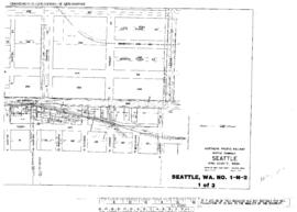
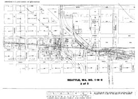
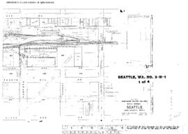
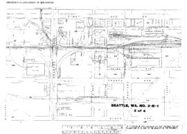
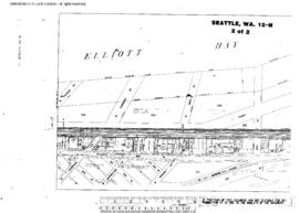
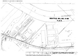
Plat Map of Northern Pacific facilities at Seattle, Washington, May 23, 1952, Sheet Number 4, showing the East Marginal Way, Boeing, steel spurs.
Plat Map of Northern Pacific facilities at Seattle, Washington, March 1, 1950, Sheet Number 1, Line Segment 430, showing the Seattle-Argo line, Shore line, Airport Way, brewery.
Plat Map of Northern Pacific facilities at Seattle, Washington, March 1, 1950, Sheet Number 3, Line Segment 430, showing the Seattle-Argo line, Shore line, South Bradford Street-South Alaska Street.
Plat Map of Northern Pacific facilities at Seattle, Washington, March 1, 1950, Sheet Number 2, Line Segment 430, showing the Seattle-Argo line, Shore line, South Stevens Street-South Andover Street.
Plat Map of Northern Pacific facilities at Seattle, Washington, January 1, 1949, Sheet Number 1, Line Segment 51, showing the Seattle-Tacoma line, South Lander Street-South Hanford Street, old roundhouse leads.
Plat Map of Northern Pacific facilities at Seattle, Washington, January 1, 1949, Sheet Number 2, Line Segment 51, showing the Seattle-Tacoma line, South Forest Street-Spokane Street, old roundhouse leads.
Plat Map of Northern Pacific facilities at Seattle, Washington, January 1, 1949, Sheet Number 3, Line Segment 51, showing the Seattle-Tacoma line, Spokane Street-Argo, wye.
Plat Map of Northern Pacific facilities at Seattle, Washington, November 1, 1949, Sheet Number 2, Line Segment 403, showing the Seattle-Sumas line, Elliott Avenue West.
Plat Map of Northern Pacific facilities at Seattle, Washington, July 1, 1949, Sheet Number 2, Line Segment 403, showing the Seattle-Sumas line, Interbay, 12th Avenue West-West Dravus Street, Great Northern roundhouse.
Plat Map of Northern Pacific facilities at Seattle, Washington, April 1, 1949, Sheet Number 1, showing the Harbor Island, north end, 16th Avenue Southwest, dock and industry spurs.