US WaBuPNRA D0011-004-014-004-001-JMF04-02856.0
·
Item
·
1887
Part of James M. Fredrickson Collection
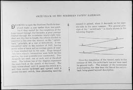
News story of Northern Pacific switchback at Stampede Pass, Washington Territory, in 1887. Description of switchback operation, diagram. J.M. Fredrickson collection.. Other Subject Classes: switchback
Fredrickson, James M.